Algeria: Desert Navigation Sprint with Shadow Sticks
Context
Section titled “Context”Algeria is a desert nation at scale: roughly 85% of its territory lies within the Sahara, a mosaic of wind‑sculpted ergs (sand seas), stony regs (stone plains), and volcanic massifs that begins just beyond the Tell Atlas and stretches to the borders with Niger and Libya, even though most Algerians live in the northern coastal belt and this format draws specifically on Saharan‑region knowledge. In this landscape, cities like Taghit sit at the foot of the Grand Erg Occidental’s towering dunes, a natural classroom for navigation and wayfinding. * * *
The south‑east’s Tassili n’Ajjer plateau, inscribed by UNESCO in 1982, preserves more than 15,000 prehistoric engravings and paintings amid striking rock formations, underscoring that people have read this desert’s cues for millennia. That heritage now inspires a modern, work-tested ritual: a half-day orientation challenge that uses Sahara-specific cues, such as sun shadows, dune lines, and star pointers, to help teams practice decision-making and mutual trust. *
As of 2024, several Algerian event agencies market team‑building outside meeting rooms, per provider materials. Oran‑based T‑Event Algeria positions custom team‑building programs nationwide; Terralgerie explicitly includes “villes sahariennes” with treasure hunts and orientation games, formats that transport corporate groups into the very terrain that shaped local desert know‑how. * *
Meet the Company/Cultural Tradition
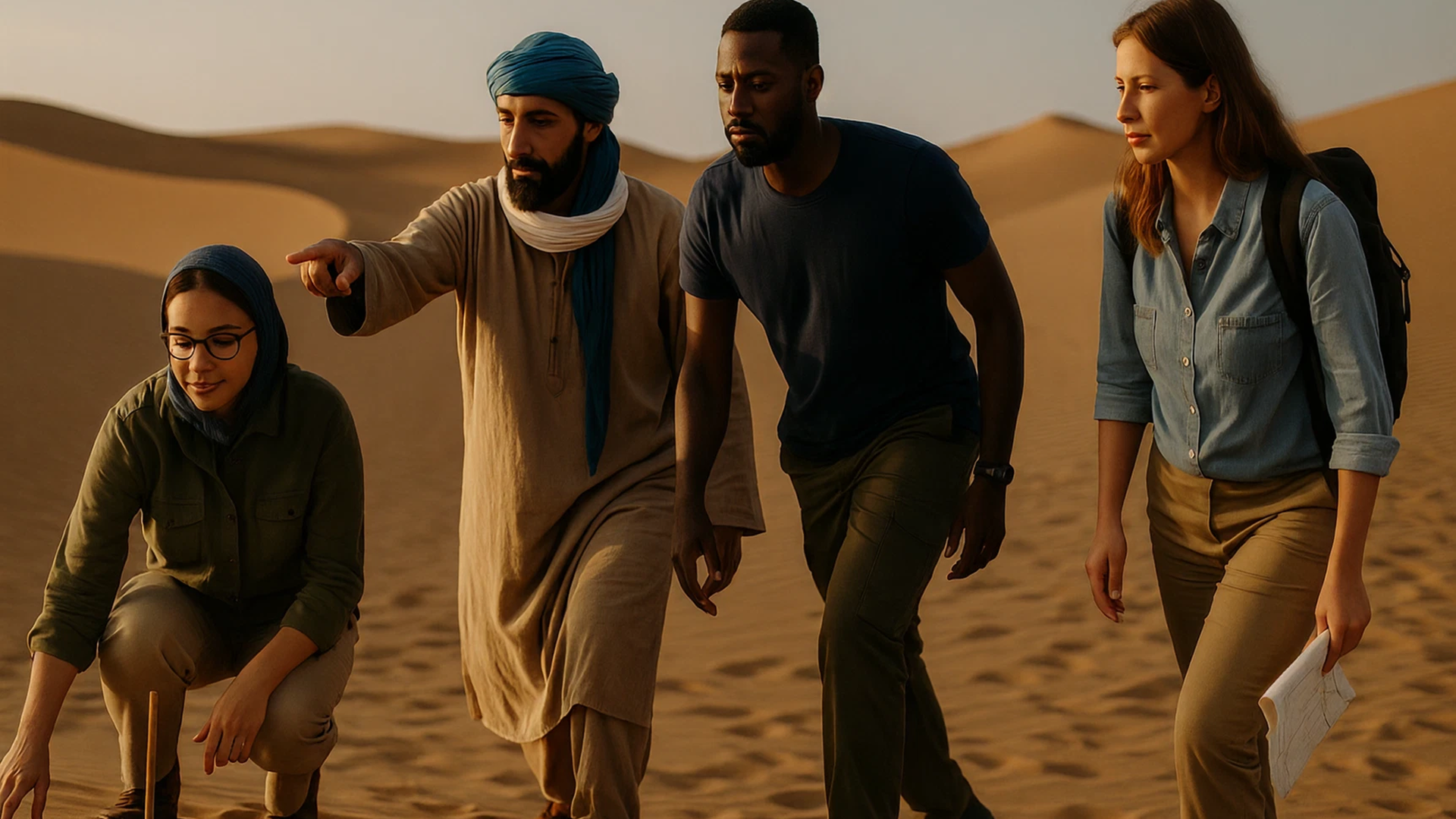
Section titled “Meet the Company/Cultural Tradition”The ritual blends two verified threads. First, Tuareg (fr. Touareg; endonyms Imuhagh/Imuhar; community self‑name Kel Tamasheq; languages Tamahaq/Tamasheq—regional variants) guided navigation practices—reading wind, dunes, and the night sky—remain part of living knowledge in the Algerian Sahara. Djanet‑based operator Warrior Road Trip describes its Tuareg team as experts who “know how to read the stars, the dunes and the winds,” and offers corporate “TeamBuilding” modules that adapt those cues into structured challenges (sans camping or ceremonies when designed as a day module). * *
Second, Algeria’s business-event providers package those practices for companies: T‑Event Algeria and Terralgerie sell made‑to‑measure cohesion activities such as orientation races and treasure hunts, often staged in Saharan settings reachable by day trip. Combined, they create an accessible canvas for team rituals rooted in Saharan knowledge, provided that teams use licensed local partners, comply with wilaya regulations for sites such as Djanet/Illizi, and agree transparent revenue‑sharing that pays Tuareg guides fairly. * *
The underlying skillset is specific to place. In crescentic (barchan) dune fields common near Taghit, crests are roughly perpendicular to prevailing winds, giving coarse direction, while forms vary by local conditions; a simple “shadow stick” (a vertical stake and two timed marks of its tip) yields an east–west baseline in minutes; and classic star pointers (e.g., Ursa Major and Cassiopeia toward Polaris) can be demonstrated safely in early evening briefings. These are not campfire stories; they are applied micro‑skills drawn from desert practice. * *
The Ritual
Section titled “The Ritual”| Phase | What Happens | Purpose | Evidence/Notes |
|---|---|---|---|
| 0–10 min | Safety brief, sun-hat check, water issued; facilitator sketches the day’s two cues: dune lines and shadow stick | Set psychological and physical safety; prime attention | Day-only, no camping or meals; desert basics first. |
| 10–20 min | Shadow‑stick drill: teams plant a short stake, mark two shadow tips 10–15 min apart, draw their east–west line | Hands-on “trueing” of direction; shared success early | Shadow‑stick method is a standard field technique. * |
| 20–25 min | Micro‑lesson at a dune crest: read slipface and crest orientation versus wind to infer a coarse bearing | Situational awareness; link terrain to navigation | Dunes align 90° to prevailing winds. * |
| 25–60 min | Orientation Quest: teams navigate 3–4 checkpoints across low dunes using their shadow line, a simple bearing, and a sketch map; roles rotate (navigator, timekeeper, safety) | Collaboration under mild load; clear comms and role‑switching | Terralgerie offers “jeu de piste / chasse au trésor” formats, adaptable to dunes. * |
| 60–75 min | Regroup at a viewpoint; quick “what changed our plan?” debrief; facilitator highlights two good decisions from the field | Convert experience to learning; reinforce behaviors | Keep to water-and-shade stop; no food ritual. |
| 75–90 min | Optional star‑pointers demo (if near dusk): show how Ursa Major or Cassiopeia lead to Polaris; or simulated with a planisphere card in daylight | Connect day skills to night sky lore without night travel | Tuareg star‑pointer practices are attested in the central Sahara and should be introduced only in a general, non‑esoteric way. * |
| 90–100 min | Close‑out: each team marks its “best micro‑decision” on a pocket card; bus back to base | Memory anchor; frequent, lightweight closure | Designed for repetition; no camping required. |
Providers in Algeria who can deliver components of this format include T‑Event Algeria (corporate team‑building nationwide), Warrior Road Trip (Tuareg‑guided desert know‑how), and Terralgerie with treasure‑hunt/orientation games in Saharan cities, and you should assign an accountable owner with facilitator, communications, and data leads, estimate loaded time and vendor costs per participant, and offer a 60‑minute MVP with two checkpoints and one guide that is 30–50% cheaper. * * *
Why It Works
Section titled “Why It Works”This ritual is not a generic “outdoor break.” It leverages Algeria’s unique terrain to create embodied problem‑solving in motion. Orienteering-style navigation has been described as “the thinking sport,” engaging spatial reasoning and executive function; short, map‑and‑compass tasks in unfamiliar terrain demand continuous communication and shared mental models. Cues plus rotating roles build a shared mental model that improves on‑task coordination, which should translate to fewer handoff defects per sprint and faster, clearer decisions at work. *
There’s also cultural fit. Using dune lines and shadow sticks honors Sahara‑grown heuristics that Tuareg and other desert travelers still teach. When a Tuareg guide explains why one team’s bearing drifted as a gust shifted a barchan’s slipface, participants gain respect for local expertise and for each other. The ritual fuses place‑based knowledge with modern teamwork when co‑designed and credited with local partners, in formats Algerian agencies already market for cohesion. * * *
Outcomes & Impact
Section titled “Outcomes & Impact”A meta‑analysis shows that structured teamwork training can produce medium effects on teamwork behaviors and meaningful gains in performance when well designed and contextualized. Field‑based, task‑focused formats particularly strengthen task cohesion: the sense that “we can execute together.” Measure impact with brief pre‑ and post‑surveys (psychological safety, task cohesion, decision clarity) and simple behavioral indicators (opt‑in rate, role‑rotation adherence, debrief turn‑taking balance), using a waitlist control where feasible and thresholds such as +0.3 on safety and cohesion and ≥80% role‑rotation adherence. * *
For Algerian employers, start with cross‑functional product or project teams outside peak customer windows, exclude safety‑critical crews (e.g., NOC during live operations), and tie the ritual to priorities like cross‑team collaboration and decision cycle time. Several agencies, including T‑Event Algeria and Terralgerie, offer modular programs that can recur quarterly with course variation, though teams should monitor novelty and fatigue. Rotating sites (e.g., Taghit’s accessible dunes in the Grand Erg Occidental) keep novelty high while staying logistically simple for day trips. To support inclusion and policy fit, schedule outside Friday midday and around Dhuhr and ‘Asr, provide a shaded or indoor equivalent for mobility or health needs and during Ramadan, and offer privacy for prayer and modest dress guidance. * * *
Lessons for Global Team Leaders
Section titled “Lessons for Global Team Leaders”| Principle | Why It Matters | How to Translate |
|---|---|---|
| Place-as-teacher | Authentic, local cues make skills sticky | Use dunes, not slides; teach shadow-stick and dune reading in situ |
| Short, repeatable cycles | Habit beats off-sites; frequent reps build trust | Keep it <2 hours; rotate checkpoints each month |
| Role rotation | Prevents “hero navigator” dependency | Assign navigator, timekeeper, safety; swap every leg |
| Task-first bonding | Shared execution fosters cohesion without social pressure | Score on decisions made, not distance covered |
| Professional guides | Safety and cultural accuracy | Contract local desert operators; require hydration and heat protocols |
Implementation Playbook
Section titled “Implementation Playbook”- Choose a permitted day‑trip site with easy dune access (e.g., low dunes near Taghit at the Grand Erg Occidental), verify local permits and operator licensing, use Leave No Trace practices (no ground disturbance, remove stakes/markers, pack out waste, stay on existing tracks), do not stage activities inside protected archaeological zones, and confirm transportation and shade points.
- Book a certified provider and prepare a one‑page communication linking to strategy, stating voluntary opt‑in/opt‑out and the equivalent alternative (plus an accessible remote simulation for distributed teams), explaining time/place/heat protocols and data retention, crediting local partners, and publishing a heat‑safe indoor contingency plan; in Algeria, T‑Event Algeria (corporate team building) and Tuareg‑led operators like Warrior Road Trip can co‑facilitate safely with co‑design, explicit credit, and written benefit‑sharing, and do not replicate the activity without local partners.
- Set guardrails and safety thresholds: voluntary participation with a socially safe opt‑out and equivalent alternative, HR/Legal approval and confirmed working‑time/pay treatment, day‑only window with max 90–100 minutes on sand, WBGT/heat‑index go/no‑go thresholds with early‑morning starts, hydration every 20 minutes, minimum one certified first‑aider per 10 participants, guide‑to‑participant ratio ≤1:10, radios or sat‑comms, a mapped evacuation route and backup vehicle, on‑site shade, and no movement within 60 minutes of sunset.
- Prepare kits: short stakes, markers, sketch maps, compasses, sun protection; print a one‑page “shadow‑stick” card for each trio.
- Design 3–4 checkpoints within sight lines; ensure a facilitator can observe from a crest and intervene if heat stress appears.
- Assign roles (lead facilitator, safety officer with first‑aid certification, and local guide), keep a ratio of facilitators/guides to participants of ≤1:10 with a maximum group size per wave of 20, script role rotations (navigator → timekeeper → safety) at each checkpoint, and score on clarity of plan and micro‑decisions, not speed.
- Close with a five‑minute debrief at shade: collect only anonymous team‑level notes for the stated learning purpose, do not score individuals, name a data owner, and store aggregated results for no more than 90 days.
- Run a 90‑day pilot with 2–4 teams completing 2–3 repeats, keep must‑have elements (local guide, safety brief, role rotation), use debrief prompts, set success thresholds (+0.3 belonging, ≥70% opt‑in, −15% handoff defects), and stop for heat‑index breaches, any safety incident, <40% opt‑in, or a safety pulse drop.
Common Pitfalls
Section titled “Common Pitfalls”- Avoid when WBGT/heat index exceeds safe thresholds (e.g., WBGT > 28°C); schedule early morning only, keep teams small (3–5), and maintain a hard cutoff to be back 90 minutes before sunset.
- Explicitly prohibit speed rankings or shaming; use cooperative scoring only and reward navigation quality, not pace.
- Skipping local expertise; always co‑design with and credit licensed local guides and respect boundaries around sacred or ceremonial knowledge.
- Expanding scope to dusk travel or star walks; keep the star demo stationary in a lighted briefing area and keep the format lean to stay inclusive and policy‑safe.
Reflection & Call to Action
Section titled “Reflection & Call to Action”In Algeria, the desert environment provides a practical setting for applied navigation and coordination practice. A stick’s moving shadow and a line in the sand can synchronize how a team decides, speaks, and trusts. If your people are scattered across functions or offices, try a two‑hour Erg Orientation Challenge co‑designed with local partners and crediting origin, or adapt the mechanism to your local terrain with equivalent cues. You’ll return with a shared language for decisions and clearer coordination habits.
References
Section titled “References”- About Algeria — Embassy of Algeria in Doha.
- Earth from Space: Algerian sands — European Space Agency.
- Grand Erg Occidental — Wikipedia.
- Tassili n’Ajjer — UNESCO World Heritage Centre.
- Team Building — T‑Event Algeria.
- Corporate — Terralgerie (experiences for teams, including desert-based activities that build cohesion).
- Warrior Road Trip (home).
- Notre Équipe — Warrior Road Trip (Touareg guides: reading stars, dunes, winds).
- What to know about orienteering, the “thinking sport.” TIME.
- Direction finding by the sun — Land Navigation (shadow‑stick method).
- Desert survival: secrets of ancient Bedouin navigation — The National.
- McEwan D., Ruissen G.R., Eys M.A., Zumbo B.D., Beauchamp M.R. (2017). The Effectiveness of Teamwork Training on Teamwork Behaviors and Team Performance: A Systematic Review and Meta‑Analysis. PLOS ONE.
- NASA (2021, updated 2024). What is the North Star and How Do You Find It?
- U.S. Geological Survey. Geology of Great Sand Dunes National Park (section on dune types and wind alignment).
- U.S. Army Field Manual excerpt: Determining Direction in the Field — Shadow‑Tip Method (FM 44‑48, Appendix C).
- Training Circular TC 3‑25.26: Map Reading and Land Navigation — Army Publishing Directorate (official manual; includes field‑expedient direction finding).
- Hohl R., de Oliveira R.M., Gonçalves S.S., Kaheler Sá P.M., Shigaeff N. (2025). Neuropsychological Assessment in Orienteers: Implications for Sports Performance and Cognitive Health. Perceptual and Motor Skills.
- Royal Astronomical Society of Canada. Star Finder (planisphere) and usage guide.
Looking for help with team building rituals?
Notice an error? Want to suggest something for the next edition?
Authored by Paul Cowles, All Rights Reserved.
1st edition. Copyright © 2025