Turkmenistan: Walk of Health Sunrise Ashgabat Team Climb
Context
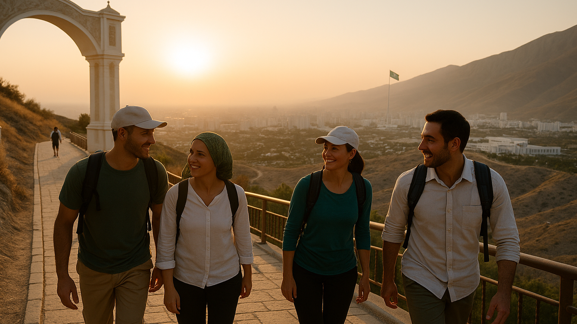
Section titled “Context”At the southern edge of Ashgabat, a pale ribbon of concrete climbs the first folds of the Köpetdag mountains. This is Saglyk Ýoly (Walk of Health; pronounced “sagh‑lik yoh‑luh”), built in 1999–2000 to promote public fitness and civic togetherness. It runs for roughly 36 km along the ridge line, with an approximately 8 km section and a longer 28 km section; pavilion spacing, railings, and lighting vary by segment and year, so confirm current conditions with a licensed local operator. The ridge reaches approximately 1,293 m above sea level in places, and a prominent flagpole overlooks the city near one high point. The original concept required ministers to walk it annually; today it functions as a shared urban ritual for residents, students, and visiting delegations, and some mass ascents are state‑organized and symbolic, with sections refurbished over time, so keep team participation voluntary and apolitical. * *
The path has become a stage for mass ascents that mix institutions and generations, and local walkers describe it variously as a leisure amenity, a civic ritual, and a political symbol. On 2 November 2024, a dawn hike gathered more than 6,000 participants, government bodies, diplomats, university groups, and the public, in a show of healthy living and collective pride. The event was organized shortly after Turkmenistan’s UN-backed “United Nations Friendship Games” resolution, turning a political milestone into a people’s walk. * * *
Beyond set-piece days, the ridge trail functions as Ashgabat’s unofficial team-bonding corridor. Embassies and multilateral missions hike it together, with ten ambassadors trekking the route on 23 February 2025, three completing the full 28 km section, while local tour companies regularly program the 8 km leg for groups who want a shared challenge that ends in citywide views. * * *
Meet the Cultural Tradition
Section titled “Meet the Cultural Tradition”Saglyk Ýoly is not a national park trail that happened to catch on; it is purpose-built social infrastructure. The first 8 km were inaugurated on 2 January 2000 and expanded later that year, with rest shelters and lighting added to make group use feasible. The two signed sections include an approximately 8 km segment and a 28 km segment that start near the trailhead park and run in opposite directions along the foothills; confirm current Turkmen names and signage with a licensed local operator and use those forms in participant materials. The terrain begins with steep concrete stairs to the ridge, then rolls with balcony-like views across Ashgabat’s white-marble skyline. * *
What makes the path distinctive is how it convenes disparate teams under a single, non-competitive banner. Mass ascents bring together ministries, universities, media, and foreign missions; the November 2024 event even included a friendly race element for route completion among diplomats and state officials. Between these spectacles, the approximately 8 km section is an everyday venue for sunrise “micro‑hikes” by offices that want a shared physical reset without the logistics of leaving town. Commercial operators such as Ayan Travel, Visit Turkmenistan and others fold the Walk of Health into group itineraries, making it straightforward for HR or culture managers to book a guided ascent with transport and safety cover. * * *
The Ritual
Section titled “The Ritual”| Minute | Scene | Purpose |
|---|---|---|
| 0–10 | Meet under the Serdar Health Park arch; quick kit check (water, hats), pair up cross‑department | Set safety and mixed teams |
| 10–20 | Gentle warm‑up on the first stair section | Shift from office mode to shared effort |
| 20–45 | Steady climb to the ridge with 1–2 minute pauses at each golden‑domed pavilion | Micro‑recovery and informal mingling |
| 45–60 | Ridge walk: conversation naturally rotates as paces change | Cross‑role connection in motion |
| 60–70 | Summit stop near the flagpole: group photo, 60‑second gratitude round (one sentence each) | Recognition without speeches |
| 70–90 | Descent to the finish kiosk; hydrate and cool down | Closure and physiological reset |
| 90–95 | Log attendance; optional sign‑up for next month’s ascent | Make it rhythmic and inclusive |
Note: Many teams choose the approximately 8 km section at sunrise to avoid heat; offer an accessible flat‑loop or shuttle‑to‑ridge option with equal credit, follow heat index/AQI cutoffs agreed with HSE, and keep the ritual arc in view (gather → climb → ridge → summit → descent). *
Why It Works
Section titled “Why It Works”Walking side‑by‑side can soften hierarchy compared with conference rooms for many teams. The setting is egalitarian, with few formalities, and the cadence of effort and recovery creates natural conversational turns. Research consistently links walking with better idea generation: controlled experiments at Stanford found creative output rose around 60 percent during and shortly after walking versus sitting. Teams that need fresh thinking on thorny problems often find they generate more ideas when they leave the table and move. *
Group walks in natural settings also correlate with improved mental well‑being. Large‑scale studies of organized nature walks report lower depression and perceived stress, and higher overall mental well‑being among participants, especially after stressful events. In other words, a monthly ascent can act as a pressure valve as much as a brainstorm. * * *
Finally, Saglyk Ýoly is specific to place. The lamps, ridge pavilions, and long sightlines over Ashgabat give the ritual a Turkmen signature. When ministries, universities, and diplomatic teams climb the same stairs, even on different days, they participate in a shared civic rhythm that subtly reinforces belonging. * *
Outcomes & Impact
Section titled “Outcomes & Impact”The most observable benefits tend to show up in mood and idea generation, aligning with priorities like cross‑team collaboration and well‑being. After even brief walks, people generate more novel ideas, something the Stanford team quantified with standard creativity tasks. Managers who turn some complex syncs into “walk‑and‑talks” often report fewer stuck conversations and more actionable options, though effects vary by team and context. While every organization should measure its own outcomes, use a simple mechanism‑to‑metric chain (walking pairs → more option sets in design reviews) and treat the mechanisms as plausible and mainly lab‑supported—mild exertion plus fresh air are associated with increased divergent thinking. *
On the mental‑health side, evidence from the UK’s Walking for Health program, nearly 3,000 weekly walks involving tens of thousands, found participants in nature group walks had significantly lower depression and perceived stress and higher overall well‑being compared to non‑participants. Teams that adopt a monthly Saglyk Ýoly ascent are adopting a simple, low‑risk practice that may support camaraderie and resilience, while offering equivalent alternatives for those who opt out. * *
The ritual also taps into wider civic narratives. Mass ascents have become a familiar way to mark national initiatives; the 2 November 2024 climb mingled government, universities, and foreign missions, useful social glue in a small capital where relationships power collaboration. Even outside headline days, embassies and institutions continue to hike together, giving newcomers a quick entry into Ashgabat’s professional community. * *
Lessons for Global Team Leaders
Section titled “Lessons for Global Team Leaders”| Principle | Why It Matters | How to Translate |
|---|---|---|
| Make it place‑based | Rituals stick when they reflect local identity | Choose a signature path, hill, or waterfront unique to your city |
| Protect the cadence | Repetition beats off‑sites | Put the ascent on a monthly rota; rotate hosts |
| Design for inclusion | Mixed fitness levels need micro‑pauses | Use short segments, shade, and frequent rests |
| Keep words short | Presence over podiums | One‑sentence gratitude at the summit; no speeches |
| Partner locally | Logistics matter for safety | Use licensed tour operators for permits, timing, and first aid |
Implementation Playbook
Section titled “Implementation Playbook”- Scout the approximately 8 km section at sunrise with HSE in mind; complete a brief risk assessment noting shade, pavilions, bailout points, emergency contacts, and extraction options, confirm event insurance and vendor liability, and schedule during paid hours or offer overtime/comp time. *
- Book a guided slot through a licensed local operator; confirm any permits and group‑size limits, carry ID, observe no‑drone rules and photography restrictions near government/border sites, and arrange bus drop‑off at the trailhead arch and pick‑up at the finish kiosk. *
- Publish a one‑pager that names the accountable owner and data steward and includes the route map, heat index/AQI cutoffs, minimum water per person (0.5–1 L per hour), modest attire guidance, closed‑toe shoes, a simple buddy system, explicit voluntary/opt‑out language with an accessible alternative and a manager briefing to avoid coercion, and how anonymous feedback will be used and retained for 60 days with Legal/HR review and credit to Saglyk Ýoly and local partners.
- Set a max group size of 24 with a 1:12 marshal ratio (front and sweep) equipped with a first‑aid kit and radio/phone; set pavilion pause points every kilometre and brief an emergency plan with incident log and escalation steps, and rotate facilitation with leaders pairing with juniors to limit airtime.
- Add a light ritual at the summit: make the one‑sentence “thanks” optional, use opt‑in photo consent (e.g., wristbands), avoid photographing sensitive facilities or toward the border, and do not tag or geotag or share externally without explicit consent.
- Close with hydration and ten minutes of stretching; send a 3‑item anonymous pulse within 48 hours (mood, perceived connection, idea generation), store only aggregates for 60 days, do not collect health data or use attendance for performance, and allow anonymous RSVP/participation.
- Pilot with three non‑customer‑critical teams over eight weeks (two repeats each) using an MVP 4–5 km ≤75‑minute route without a bus, estimate loaded time cost per participant and obtain a vendor quote, set success thresholds (e.g., +0.3/5 mood and +20% design reviews with ≥3 options), define halt criteria (e.g., HI ≥ 32 °C/90 °F or AQI ≥ 150), then repeat monthly with an accessible alternative that receives equal credit.
Common Pitfalls
Section titled “Common Pitfalls”- Starting too late in the morning makes the climb punishing because of heat and lack of shade; begin at sunrise or reschedule if the heat index exceeds 32 °C/90 °F or AQI is unhealthy, and check with your operator for any short‑notice closures. *
- Do not turn it into a race; keep focus on inclusion and connection, make participation and speaking voluntary, and keep the event apolitical.
- Avoid over‑talking at the summit; most of the value comes from the walk itself, and follow local guidance on where photography is permitted.
- Skipping safety roles—set a 1:12 marshal ratio, carry 0.5–1 L of water per person per hour, and brief emergency contacts and bailout points.
Reflection & Call to Action
Section titled “Reflection & Call to Action”Some rituals bind because they’re simple. A shared ascent, feet on the same steps, lungs in the same air, can align a team faster than any deck. Turkmenistan’s Saglyk Ýoly shows how a city’s landmark can support trust‑building: climb together, pause together, and see the city from the same ridge for a minute.
If your team is in Ashgabat, consider booking the approximately 8 km section next month or run an accessible flat‑loop alternative with equal recognition and scheduling during paid hours. If not, borrow the blueprint respectfully: credit Saglyk Ýoly as the inspiration, partner with local groups, adapt to local norms and access rules, and, where possible, share benefits such as donations to trail maintenance. The view from the top won’t fix everything, but it will change how you face what’s ahead, together.
References
Section titled “References”- Walk of Health (Saglyk Ýoly) – Wikipedia.
- “Walk of Health” in Ashgabat – Ayan Travel Agency.
- Mass hike announced for the Health Path on November 2, 2024 – Turkmenistan.gov.tm.
- Digest: Mass ascent with ministries, diplomats and students – Turkmenportal (4 Nov 2024).
- President of Turkmenistan leads mass climb on the Health Path – Business.com.tm (4 Nov 2024).
- Group of ambassadors treks the Health Walk – News Central Asia (24 Feb 2025).
- Serdar (Health) Walk – Koryo Tours Travel Guide.
- Owadan Tourism – Hiking Special (includes first hike across the Stairs/Walk of Health in Ashgabat).
- Stanford study: Walking boosts creativity – Stanford Report.
- Group nature walks linked to improved mental health – University of Michigan (The University Record).
- Walking off depression and beating stress outdoors? – ScienceDaily (U‑Michigan).
- Walking for Well‑Being: Group Walks in Natural Environments – International Journal of Environmental Research and Public Health.
- President ascends the Path of Health – Turkmenistan.gov.tm (2015).
- Owadan Tourism – Short and Spectacular (city tour includes Stairs/Walk of Health Park; operator offers guided logistics in Ashgabat).
- Berkarar HJ – The Walk of Health (destination page with contact and tour enquiry; local provider).
- Embassy of Pakistan in Ashgabat – press release on 28‑km Health Walk with 10 ambassadors (Feb 22–23, 2025).
- Oppezzo & Schwartz (2014). Give Your Ideas Some Legs: The Positive Effect of Walking on Creative Thinking – PubMed record.
Looking for help with team building rituals?
Notice an error? Want to suggest something for the next edition?
Authored by Paul Cowles, All Rights Reserved.
1st edition. Copyright © 2025